
Lost My Heart in Cuenca! | An Indian in Ecuador 🇪🇨 Ep. 52
June 10, 2026
In a city where four rivers flow, shaped like a basin, lies one of the world’s most remarkable places. It is a city from which the highest number of flowers are exported globally. The climate remains pleasant throughout the year, ranging between 10°C and 20°C. …
Search
Categories
Tags
000 km From LONDON. Pole to Pole Ep.4
A Journey Through Fiji’s Capital City
Antarctica Expedition Begins from Ushuaia
Antarctica Expedition Begins from Ushuaia | Pole to Pole Ep. 2
Antarctica Wildlife || Pole to Pole Ep.8
Antarctica’s Secrets: Whales War
Antarctica’s Secrets: Whales War || Great Survival Story || Pole To Pole Ep.6
Antarctica’s Wildest Penguin City
Antarctica’s Wildest Penguin City: 10 Lakh Kings Penguin 🐧👑 | Pole to Pole Ep.7
Atacama Desert
atacama desert blog
cycle baba
cyclebaba
Cycle Baba Blog
Cycle Baba First Impressions of Iceland: A Journey Begins
Cycling in Iceland: Winds That Test Your Limits
Dark Reality of Australia 🇦🇺 | Indigenous Life in Darwin
Discovering the Untouched Beauty of Vanuatu’s Islands
Exploring Australia’s Wilderness by Caravan
Exploring Indo-Fijian Heritage in Suva
Exploring the Heart of Australia: A 6-Day Caravan Adventure from Darwin to Cairns
Exploring Vanuatu
FALKLAND ISLANDS
Fight Between Two Giant Elephant Seals
Fiji
Fiji Look like mini india
Iceland Tour Of Cycle Baba
Life on Isolated Falkland Islands 🇫🇰 | A British Land 13
Mini India in Fiji
My Journey Through the Heart of Vanuatu
One Wild Planet
On the Way to Antarctica || Pole to Pole Ep.3
Reaches Antarctica! Unbelievable Journey Begins || Pole to Pole Ep.9
Samoa The World’s Fattest Country
Samoa 🇼🇸 – The World’s Fattest Country
The Most Extreme City on Earth Before Antarctica | Pole to Pole Episode 1
Tour of Australia
Unexplored World : FALKLAND ISLANDS 🇫🇰
Vanuatu
Vanuatu Travel Experience
World Most Remote Island
worldtour
World’s Biggest Iceberg A-23A
World’s Biggest Iceberg A-23ADelhi + Mumbai Se Bhi Bada. Pole to Pole Ep.5
World’s Most Remote Island
- REAL Center of the Earth! 🌏 India 🇮🇳 to Ecuador 🇪🇨 Ep. 55So friends, we have arrived at Mitad del Mundo, which in Spanish means “Middle of the Earth”. Namaskar, Salaam, Sat Sri Akal, Ram Ram Ji! Once again, welcome to Quito, the capital city of Ecuador. In the last video, you saw that I had arrived here. I have spent the last two days resting in this building. I rented an apartment through Airbnb and now I want to explore the city. Yesterday, the Indian Embassy celebrated International Yoga Day here, and I was fortunate enough to attend the event. I woke up early in the morning because the embassy staff had invited me the previous day. A wonderful programme was organised there. A statue of Mahatma Gandhi has also recently been installed at the embassy. Interestingly, there was no Indian Embassy here before. I believe it is a very positive step that India is opening embassies around the world because it is important to have a physical representative in foreign countries. Here, our representatives have arrived, and the embassy itself was opened only about six months ago. During my travels around the world, I have noticed that Yoga Day has greatly improved India’s image internationally. Thanks to yoga, many more people have started learning about India. I am slightly out of breath because we are currently at an altitude of about 2,700 metres above sea level. Back home in northern India, we usually live at around 200 metres above sea level since most of the northern plains are relatively flat. Walking here at this altitude definitely makes breathing a little more difficult. Today, we will explore the city. One important thing to know is that Quito is not considered very safe. Because of that, I have decided to use the city sightseeing buses instead of wandering around on my own. These buses will take us around the city, and we will also visit a historic site located about 20–30 kilometres outside the city known as the “Middle of the Earth.” So stay tuned, keep spreading love, don’t forget to hit the like button, and if you share the video, even better! The area where I am staying is called La Carolina. It has an enormous park. Normally, jogging tracks are around 400 metres long, but here they have tracks stretching for nearly 1.5 kilometres. Many people come here early in the morning to exercise. The track is synthetic, and it feels great to walk on. This is not a stadium—it is simply a public park. The city views from here are fantastic. The park is huge, probably around 2 kilometres long and nearly 1 kilometre wide. There are playgrounds, sports grounds, green areas, and even an aircraft displayed inside the park. Every part of the space has been used efficiently. The buildings in this area are also very impressive. I deliberately chose La Carolina because it is considered one of the safer areas of the city. Crime can be an issue here, and staying in hostels sometimes leads to thefts and other problems. I arrived at the ticket office for the sightseeing buses. The bus leaves at 9:00 AM and returns around 4:00 PM, stopping at six or seven locations along the way. There are actually two different tours available. One tour takes visitors to the Equator Line and includes various experiments demonstrating its unique location. The second tour is a city sightseeing tour. The Equator tour costs $25, while the city tour costs $15. Together they cost $40. Local residents get discounted rates. I asked how to pronounce the place name correctly: “Mitad del Mundo?” “Yes, Mitad del Mundo.” The staff explained that one ticket included entry to the attraction while the other covered the city tour. I decided to purchase the Equator tour first and leave the city tour for later. Before departure, I wanted something to eat. I stopped near a Bajaj showroom because I couldn’t find a supermarket nearby and only had about ten minutes before the bus left. I grabbed a coffee and a snack, and soon our bus arrived. The bus set off under a blazing sun. Since we are close to the Equator, the sunlight here is particularly intense. Gradually, we began heading north from Quito. Only three or four passengers were on board despite it being a double-decker bus. As we left the city, the guide explained that Quito is about 70 kilometres long from one end to the other and sits at roughly 2,800 metres above sea level. We were travelling through the northern part of the city. The guide also pointed out the city’s transport system. Dedicated bus lanes run through the city, and private vehicles are not allowed to enter them. Anyone who does faces a heavy fine. This allows buses to operate efficiently and continuously. It functions almost like a metro system on the surface. We passed the northern bus terminal, along with numerous restaurants, cafés, and handicraft shops. Eventually, we arrived at our destination. The guide informed us that the return bus would leave at 12:35 PM, giving us enough time to explore the site. The museum and surrounding area were filled with tourists. The entrance featured a marker indicating the Equator line. The site itself is very impressive. Some sculptures have even been created from recycled materials. One section of the museum focused on the indigenous cultures of the Amazon region. The guide explained an ancient tradition involving shamans. According to historical accounts, when an enemy died, the head would be removed, and the skull and other internal materials extracted. The skin would then be boiled, shaped, and filled with hot sand. As it shrank, it formed a small preserved head. The guide described the entire process, explaining how the skin would shrink after boiling and shaping. These shrunken heads were traditionally worn around the neck as part of certain cultural rituals. This practice was eventually banned around the 1960s. Today, if similar demonstrations are made, they are typically done using animal materials rather than […]
- Cycle Trip to the Top of the World 🇪🇨. Everest se bhi UNCHA? Ep.54Hello, Namaskar, Salaam, Sat Sri Akal and Ram Ram Ji! Once again, welcome back to my channel. At the moment, I am in Alausí, a small town in Ecuador, where we arrived last night after getting completely drenched in the rain. Today, our destination is Riobamba. We have a 150-kilometre ride ahead of us, including some challenging climbs. There is also a good chance of rain today, as it is currently the rainy season in Ecuador and the country has been receiving heavy rainfall. Right now, I am in Ecuador, country number 135 of my world journey. I got ready early in the morning. Behind me, you can see my hotel. This road is quite busy, and there will probably be traffic for the first 30 to 40 kilometres. After that, we will move onto a different route where most of the traffic diverts away. Let’s get going and see what the day brings. Come on, Dhanno, let’s go super fast! Look at this! Every city here seems to have a Plaza de Armas. We start the day with a climb — about 34 kilometres long, gaining around 400 to 500 metres in elevation. After that, it will mostly be downhill. The scenery is absolutely stunning. It fills my heart with joy. But the climb is brutal. Should I start crying already? It is a seriously tough ascent. Look back there — that’s where I came from. By 11 a.m., I had already covered 60 kilometres in four hours. There is still another 300 to 400 metres of climbing left before a 600-metre descent. At this point, I am walking the bike. I will probably have to walk another four or five kilometres. Look at these sheep. People keep them at home here. I am currently at an altitude of around 3,400 to 3,500 metres above sea level. Look at the sweat pouring off me. I normally don’t sweat much, but today I am completely soaked. It’s cold outside, yet my body is overheating from the effort. I have already walked four kilometres and still have another two to go. Finally, a petrol station! Maybe I can get a coffee. “Do you have a cappuccino?”“No.”“Okay, no problem. Gracias.” Well, this is the coffee. They simply mix coffee into hot water and that’s it. And look at the shop — it’s very basic. Nothing like the large service stations you find in some countries. And now, the rain has started again. Rain outside, sweat inside, cold weather all around. Well, I have now completed 100 kilometres, but I honestly don’t know if I will reach my destination today. There are still another 50 to 60 kilometres remaining. It is already 4 p.m., so I may be a little late, but hopefully I’ll get there before nightfall. Evening has arrived, and I still have around 30 kilometres to go. I have entered a small town now. It is raining heavily and I am completely soaked. The weather here is relentless. I can’t even stop for a day and wait for better weather because the forecast shows rain for the next ten days straight. I had booked a hotel, but I ended up taking a different route. Fortunately, I found an apartment on Booking.com and decided to stay there. It cost me $25. It is a full apartment with two rooms. It is already 6 p.m., and the rain is getting heavier, so I’ll head to a nearby shop and buy something to cook. I found a vegetable shop close by. I bought some fruit, onions, tomatoes and a zucchini. I still have tortillas with me, so I will make a simple meal. The exhaustion is really catching up with me. I probably pushed myself too hard today. I chopped the onions, tomatoes and zucchini. I also have some ghee and a special spice mix that I prepared earlier by blending various spices with olive oil. First, I add a little ghee, then the spice mixture. I lower the heat so it doesn’t burn. These days, I have become quite the professional chef! Then I add the tomatoes, let them cook a bit, add the zucchini and a little water. Ten minutes later, the meal is ready. And there we have it — dinner is served. Time to enjoy it. Ram Ram Ji to everyone! Once again, welcome to Ecuador, country number 135. Today we continue towards Riobamba. Yesterday I wasn’t able to reach the city. For the first time in three days, I finally got to see the sun this morning. It is 8:30 a.m., and I am setting off again. Ahead of us is a volcanic mountain. If you remember San Pedro de Atacama, there was a volcanic mountain there too. We need to climb around this volcano and continue on the other side. This was the apartment where I stayed last night. For $25, I got a two-bedroom apartment. One room was completely empty. Considering I arrived soaked from the rain, finding this place was pure luck. Otherwise, I would have had to continue all the way into the city. Today I am not going into Riobamba itself. It would require descending 500 metres and then climbing back up again. Instead, I will bypass the city and rejoin the highway directly. So, I have left the apartment and am riding around the outskirts of Riobamba. Ahead lies a beautiful mountain that I will show you soon. I am being careful with my camera today because I am close to the city and the risk of theft is higher. Most of the time, I keep my phone in my pocket. Can you see that snow-capped mountain in the distance? We have to pass along its base. There is about 1,000 metres of climbing ahead, which will take three to four hours. Unfortunately, clouds are starting to gather again. Have you seen clouds like these in India recently? It’s incredible. I have stopped to repair my bicycle. Something is wrong with […]
- INDIAN Solo Cycling in ECUADOR, Pole 53Hello, Salaam, Sat Sri Akal and Ram Ram to everyone. At the moment, I am in Ecuador, which is our 135th country. From here, I will be travelling from Cuenca to Quito, the capital city of Ecuador. The capital is around 400-450 kilometres away, but since it is a mountainous region, it will take quite a bit of time. It will definitely take at least two or three days and may even take four or five days. Today, I am starting my journey from here. It is 9th June today, and I have finally seen sunshine for the first time after spending three days here. I will probably reach Quito by the 11th or 12th of June. Now I am mentally prepared to continue my journey because all the stress and disappointment of being robbed is finally behind me. I took proper rest for two or three days and am ready to move on. Let me tell you about Ecuador’s visa process. Ecuador only offers an e-Visa. To get it, you must have a PCC (Police Clearance Certificate), and it must be apostilled. I contacted the Indian Embassy and got my PCC, but it was not apostilled. Then I spoke to people back in India and requested help from my friend, Somveer Bhai. After speaking with several people, I finally managed to get the Ecuador visa. The processing time is usually more than 60 days. I also met the Ecuadorian Ambassador in Peru and requested him to make a phone call on my behalf. After his recommendation, I finally received my visa. I had forgotten to explain this in my previous video. Now, let’s say goodbye to this beautiful city. Honestly, I haven’t seen such a beautiful city in a very long time. Arequipa in Peru was also beautiful, but this city is, in many ways, even more beautiful. Everything looks empty today. I have mounted the camera in front of me so that I can keep talking to you while riding. Otherwise, it was becoming difficult to interact with you. There is also a tram system in this city. I have stopped on the way at a shop owned by Rakesh Bhai, who is from India. Some beggars came here, but since he is not here, I will continue my journey. I had thought of introducing him to all of you before leaving. One thing is very famous here – these hats that you can see everywhere. The lady here is also wearing one. These are called Panama Hats. Why are they called Panama Hats? Back in 1915-1920, when the Panama Canal was being built, the President of the United States visited the site. Because of the extreme heat there, these hats were gifted to him. After that, they became famous as Panama Hats. However, the hats actually originated here in Ecuador. Their value is incredible – some of these handmade hats sell for between $500 and $1,000. This entire market is full of handmade products. Now we will head straight to the highway. I was telling you earlier that trams operate here. Look at this – it feels like being in Europe. Just look at the city. And now, it looks like rain is coming again. Rain has been a big problem here. Well, I have now left the city behind and will ride at full speed. I can see that there are many showrooms of Chinese car companies here. Amazing! Another interesting thing – this city is known as a “Retirement Paradise”. People from the USA and Canada who retire and receive pensions often come here to spend the rest of their lives. I am now around 20-25 kilometres away from the city. The highway has been excellent so far. I have now turned towards a place called Babina. I am going to eat some bananas and then continue. These are cardamom bananas. Ecuador produces a huge amount of bananas and is one of the world’s leading banana-producing countries. Most of the coastal region here is covered with banana plantations. The weather is strange. It keeps drizzling and then suddenly stops. After eating the bananas, I will continue because the views are absolutely amazing. I am slowly gaining altitude. Sometimes it rains, and sometimes it stops. I am actually afraid to take out my camera because I have already suffered enough damage. I only have one camera left. I also have a 360 camera, but I cannot really use it. Today, we have to climb up to around 600 metres. My target for the day is 70 kilometres. On the way, I met a man who advised me not to continue straight ahead. He told me about a historical site belonging to a local tribe that is worth visiting. It is about 10-15 kilometres away, so I decided to go there. I am currently climbing a 401-metre ascent, but the views are absolutely stunning. Unlike Peru or Chile, which often felt empty, this place is full of houses and people. Look at this beautiful valley. The scenery behind me was even more spectacular, but because of the rain, I couldn’t take out my camera. There are also many ponds here. Soon we will descend from here. I am out of breath because we have already reached an altitude of about 3,400-3,500 metres above sea level. Cuenca itself is at around 2,500 metres, and now we have climbed much higher. There is a town called Cañar about 20 kilometres ahead. I will visit this place and then continue. From here, after a few kilometres, there will be a downhill section. I am really enjoying this ride. Finally, the climb is over. There is quite a lot of traffic because this is the Pan-American Highway. Soon we will turn off the highway and head towards that historical site. I wanted to show you this place because it is somewhat similar to Machu Picchu. I couldn’t show you Machu Picchu, so at least I can show you this place. […]
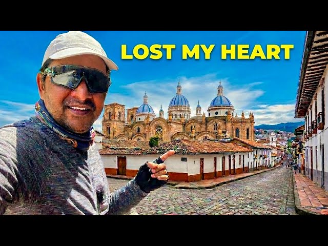
- Lost My Heart in Cuenca! | An Indian in Ecuador 🇪🇨 Ep. 52In a city where four rivers flow, shaped like a basin, lies one of the world’s most remarkable places. It is a city from which the highest number of flowers are exported globally. The climate remains pleasant throughout the year, ranging between 10°C and 20°C. It is also a city where you can drink water directly from the rivers and even from the tap. Surrounded by beautiful mountains, welcome to Cuenca, Ecuador. Namaskar, Salaam, Sat Sri Akal, and Ram Ram to everyone. Once again, welcome to the 135th country of my world cycling journey – Ecuador, and to its beautiful city, Cuenca. It is Ecuador’s third-largest city, with a population of around 700,000 people. I would call this the city of churches. I have travelled extensively, but I have never seen so many churches in a single city. There must be at least 50–60 churches in this relatively small city. Wherever you go, you will find another church. So, let us begin with this beautiful church in front of us, built on 25 December 1924. Let’s go inside and have a look. Inside, there is a museum as well. Unfortunately, it remains closed on Saturdays and Sundays. In the previous video, you saw that I had arrived in Cuenca and checked into a hotel. Nearby, there is this bridge, although the road ahead has been closed after the river. It is a bridge from the Spanish colonial era. Around here, you can still find many Spanish-era buildings and houses. Some examples can be seen all around, and you will also notice French architectural influences. Nowadays, many of the houses have been renovated, but some traditional structures still remain. We need to continue along this route. You can see that part of the bridge has collapsed ahead. Four rivers flow through this city, and there is an interesting fact about them – all four eventually join the Amazon River. What’s fascinating is that the Pacific Ocean is only about 100 kilometres away, while the Atlantic Ocean lies thousands of kilometres to the east. Yet, the water from these rivers does not flow into the nearby Pacific. Instead, it travels nearly 5,000 kilometres through the Amazon Basin before finally reaching the Atlantic Ocean. That’s because we are currently in the Andes Mountains, at an altitude of around 2,700 metres. The terrain slopes towards the Amazon side, directing the rivers eastward. Alongside the river, there are beautifully designed stairways. What makes them special are the incredible murals and paintings covering the walls. Across Latin America, wall art is truly impressive. There are also thoughtful facilities here. One side has a lift system for wheelchair users so they can avoid the stairs, while another section has a dedicated ramp for cyclists. The murals are stunning. One of them is called “Lady of the Leaf”. Nearby is a Punjabi restaurant, and my hotel is located in the same area. There are also several Pakistani restaurants in the neighbourhood. And once again, another church appears. There is always something happening here – religious ceremonies, cultural events, and community gatherings. Indigenous traditions still have a strong influence on local life. A ceremony has just taken place, perhaps connected to a local ritual or celebration. This map shows the old city. Just within this area alone, there are more than a dozen churches. Even utility boxes throughout the city are decorated with beautiful artwork. Here stands one of the city’s two cathedrals. Cuenca has countless churches and two major cathedrals. In some areas, you genuinely feel as though you have stepped back in time. The historic buildings are incredibly beautiful. I tried flying my drone twice, but the entire city is a restricted zone. Drone flights are not allowed here. Still, the architecture is magnificent. This particular building houses the Consulate of Guatemala. Now we have arrived at the city centre, where the main cathedral stands. Today, there is also a festival taking place – a sweets and candy exhibition. Local desserts are on display everywhere. Volunteers from the Red Cross are present to ensure everyone’s safety during the event. This city has truly won my heart. One of the best things about it is how safe it feels. Vendors are selling kiwis, strawberries, oranges, and other fruits. The city centre is beautifully decorated with colourful flowers. Speaking of flowers, Ecuador exports around eight million flowers every day to Europe and the United States. The flower industry alone is worth approximately one billion US dollars. Take a look at these local sweets. The atmosphere reminds me of Diwali in India, when sweet shops line the streets. There are chocolates, traditional treats, and many local specialities. I am definitely going to try some of them shortly. There are not just one or two stalls here – the entire central plaza is filled with sweet vendors and festive displays. This is the city centre, and a programme is taking place here. There seems to be some construction work going on, which is probably why they have closed off the central area. Even so, the place looks absolutely beautiful. Since it is festival time, the atmosphere is even more vibrant. Look, this lady is selling lottery tickets. And over here, there are shops set up inside as well. I have now come to the other side of the church. Let’s see whether I get a chance to go inside. This church was built in the 1800s. This is the main church. Just look at how beautiful it is. Isn’t it amazing? Let me go inside – it is even more impressive from within. It is incredibly large, spacious, and beautifully designed. This is the magnificent San Francisco Church. There are flowers everywhere, making it even more attractive. I asked about the tickets. “How much is it?” “One dollar. The next tour is in one hour.” “Okay.” For one dollar, they offer a one-hour guided city tour. Since the next tour starts in an hour, I thought I might join it […]
- INDIAN Robbed in PERU? The Truth About My Ecuador Crossing, Ep.51A gun wasn’t pointed at me here, brother — it was pointed right here. This is the area where most thieves live. I changed my tyres and set off. Hello everyone, Namaskar, Salaam, Sat Sri Akal and Ram Ram Ji. Welcome back to my channel. At the moment, we are in the beautiful city of Tumbes. This is my last city in Peru. I travelled here all the way from Lima, but unfortunately, something unpleasant happened on the way. I was robbed. They took my money, my two cameras, and one of my mobile phones. I still had one phone left, so I thought it would be better not to take any more risks. I covered around 500–600 kilometres by bus. The gun wasn’t pointed here, brother — it was pointed right here. But what hurts me the most is that I lost all my footage. I lost an entire month’s worth of recordings. I hadn’t uploaded many proper videos during that month either. There were two videos from Lima and another three or four from the journey. Around five or six videos are gone forever. The financial loss was significant too. Around $1,000 in cash was taken. The only reason I got away relatively lightly was because of the dollars I was carrying. Do you know what happened? As soon as they stopped me, they took both cameras and my phone because they were visible from the outside. Then they demanded my wallet. I had exchanged money with my friend Ratan before leaving. I transferred money into his account in India, and he gave me US dollars. Fortunately, he had given me mostly $20 notes. The robbers mistakenly thought they were $100 notes because there were so many of them. Once they saw the cash, their attitude changed. They told me, “Go now, go now,” and let me leave. It was a very frightening experience. And it wasn’t even dark. It was only around 5 p.m. It usually gets dark around 6 p.m. I had just left the highway and turned onto a smaller road. Barely 200 metres after turning, they stopped me. I suspect someone tipped them off. Around 10–15 kilometres earlier, I had stopped for coffee and taken out my wallet. I think they started following me from there. Anyway, these things happen. Now it’s time to say goodbye to Tumbes because I am heading to Ecuador. Getting an Ecuadorian visa took a very long time. That’s one of the reasons I spent nearly a month in Lima. You may have noticed that I uploaded very few videos during that period. For almost three weeks, there were hardly any uploads. During my stay in Lima, I completed two important tasks. First, I obtained a Canadian visa. That process took time because I had to provide biometrics, wait for the decision, and then get the visa sticker placed in my passport. Altogether, it took around 15 days. Getting the Ecuador visa was also very difficult. I’ll tell you the full story once I reach the Ecuador border. This is the city’s Plaza de Armas. Every city, town and village here has a place like this. It is the central square, also known as the “Centro”. Children come here to play, there is a park, and usually a church stands on one side. The city spreads out around it. My hotel was somewhere over there. Things are about to become even more dangerous as I enter Ecuador. To be honest, travelling in South America has started to feel a little scary now. One incident happened in Bolivia, and now another one has happened in Peru. What’s surprising is that people generally consider Bolivia and Peru safer than Ecuador and Colombia. I am heading further north now. I’m thinking about reducing the amount of gear I carry. Fortunately, my larger Sony cameras weren’t in the bag they stole. I had already shipped them to the USA. I’ll collect them when I reach Mexico. Otherwise, I would have lost another $8,000–$10,000 worth of equipment. Altogether, my losses amount to roughly $5,000, which is about ₹5 lakh. For one whole day, I felt completely devastated. Then I told myself that whatever is meant to happen will happen. Life goes on. God will provide. If you all continue supporting me, I’ll recover from this. If not, that’s okay too. The journey must continue. About 30 kilometres from here is the border. This city is also known for its crocodile farm. Over there is the police station. It really is a beautiful city. The problem is that I don’t have any network coverage. I actually carry two phones. One has my Indian number and the other contains a local SIM card. I had an iPhone 15 and an iPhone 16. The local SIM was in the iPhone 15, and that’s the one that was stolen. The iPhone 16 remained with me. Look, there goes a Suzuki Alto. I’ve already walked 4–5 kilometres through the city. It’s quite large. Since it’s the last city before the border, that’s understandable. Earlier, most of the auto-rickshaws here were Indian-made. Now Chinese models are becoming increasingly common. Chinese products are gradually taking over the market here as well. I had already recorded all of this before, but now everything is gone. Still, I’ll try to show you whatever I can. Those robbers were riding motorcycles and wearing helmets. They came out of nowhere and cornered me. At that moment, I was terrified. Now that some time has passed, I can talk about it more calmly. We’ve now left the city behind. There’s plenty of farming in this area. Rice has been planted, and some farmers are already harvesting it. In a few places, the crop is still green. Within another 15 days, it will be ready. Summer has begun here. In fact, this region stays warm almost all year because we’re getting close to the Equator. The coast is only about 4 kilometres away. Let me explain […]