
REAL Center of the Earth! 🌏 India 🇮🇳 to Ecuador 🇪🇨 Ep. 55
So friends, we have arrived at Mitad del Mundo, which in Spanish means “Middle of the Earth”.
Namaskar, Salaam, Sat Sri Akal, Ram Ram Ji!
Once again, welcome to Quito, the capital city of Ecuador. In the last video, you saw that I had arrived here. I have spent the last two days resting in this building. I rented an apartment through Airbnb and now I want to explore the city.
Yesterday, the Indian Embassy celebrated International Yoga Day here, and I was fortunate enough to attend the event. I woke up early in the morning because the embassy staff had invited me the previous day. A wonderful programme was organised there. A statue of Mahatma Gandhi has also recently been installed at the embassy.
Interestingly, there was no Indian Embassy here before. I believe it is a very positive step that India is opening embassies around the world because it is important to have a physical representative in foreign countries. Here, our representatives have arrived, and the embassy itself was opened only about six months ago.
During my travels around the world, I have noticed that Yoga Day has greatly improved India’s image internationally. Thanks to yoga, many more people have started learning about India.
I am slightly out of breath because we are currently at an altitude of about 2,700 metres above sea level. Back home in northern India, we usually live at around 200 metres above sea level since most of the northern plains are relatively flat. Walking here at this altitude definitely makes breathing a little more difficult.
Today, we will explore the city. One important thing to know is that Quito is not considered very safe. Because of that, I have decided to use the city sightseeing buses instead of wandering around on my own. These buses will take us around the city, and we will also visit a historic site located about 20–30 kilometres outside the city known as the “Middle of the Earth.”
So stay tuned, keep spreading love, don’t forget to hit the like button, and if you share the video, even better!
The area where I am staying is called La Carolina. It has an enormous park. Normally, jogging tracks are around 400 metres long, but here they have tracks stretching for nearly 1.5 kilometres. Many people come here early in the morning to exercise.
The track is synthetic, and it feels great to walk on. This is not a stadium—it is simply a public park. The city views from here are fantastic.
The park is huge, probably around 2 kilometres long and nearly 1 kilometre wide. There are playgrounds, sports grounds, green areas, and even an aircraft displayed inside the park. Every part of the space has been used efficiently.
The buildings in this area are also very impressive. I deliberately chose La Carolina because it is considered one of the safer areas of the city. Crime can be an issue here, and staying in hostels sometimes leads to thefts and other problems.
I arrived at the ticket office for the sightseeing buses. The bus leaves at 9:00 AM and returns around 4:00 PM, stopping at six or seven locations along the way.
There are actually two different tours available. One tour takes visitors to the Equator Line and includes various experiments demonstrating its unique location. The second tour is a city sightseeing tour.
The Equator tour costs $25, while the city tour costs $15. Together they cost $40. Local residents get discounted rates.
I asked how to pronounce the place name correctly:
“Mitad del Mundo?”
“Yes, Mitad del Mundo.”
The staff explained that one ticket included entry to the attraction while the other covered the city tour.
I decided to purchase the Equator tour first and leave the city tour for later. Before departure, I wanted something to eat. I stopped near a Bajaj showroom because I couldn’t find a supermarket nearby and only had about ten minutes before the bus left.
I grabbed a coffee and a snack, and soon our bus arrived.
The bus set off under a blazing sun. Since we are close to the Equator, the sunlight here is particularly intense. Gradually, we began heading north from Quito.
Only three or four passengers were on board despite it being a double-decker bus.
As we left the city, the guide explained that Quito is about 70 kilometres long from one end to the other and sits at roughly 2,800 metres above sea level. We were travelling through the northern part of the city.
The guide also pointed out the city’s transport system. Dedicated bus lanes run through the city, and private vehicles are not allowed to enter them. Anyone who does faces a heavy fine. This allows buses to operate efficiently and continuously. It functions almost like a metro system on the surface.
We passed the northern bus terminal, along with numerous restaurants, cafés, and handicraft shops.
Eventually, we arrived at our destination.
The guide informed us that the return bus would leave at 12:35 PM, giving us enough time to explore the site.
The museum and surrounding area were filled with tourists. The entrance featured a marker indicating the Equator line.
The site itself is very impressive. Some sculptures have even been created from recycled materials.
One section of the museum focused on the indigenous cultures of the Amazon region. The guide explained an ancient tradition involving shamans. According to historical accounts, when an enemy died, the head would be removed, and the skull and other internal materials extracted. The skin would then be boiled, shaped, and filled with hot sand. As it shrank, it formed a small preserved head.
The guide described the entire process, explaining how the skin would shrink after boiling and shaping. These shrunken heads were traditionally worn around the neck as part of certain cultural rituals.
This practice was eventually banned around the 1960s. Today, if similar demonstrations are made, they are typically done using animal materials rather than human remains.
The tour then continued, and we moved on to the next section of the museum, where the guides explained how people historically entered and used these structures.
Alright? Look at this. This was one of the tribes from the Amazon region. You can see that they used to tie a rope around themselves. The reason for this was that certain fish in the rivers could enter the human genital organs and cause serious harm. The rope was used as protection. Apart from that, they generally remained naked because it rained throughout the year. Wearing clothes constantly in such a climate would have caused skin irritation and diseases.
This was one of their weapons for hunting wild animals. One end was sharp and pointed, which they used to kill animals. This is another type of weapon—a blowgun. It is hollow inside. They would place a dart coated with poison into the tube and then blow through it. The dart could travel up to 20 metres and was used for hunting.
This was their house. As you can see, it was designed so that water could flow through from both sides during heavy rains. There were openings on either side so that floodwater could pass through without damaging the structure. Their roofs were not particularly strong and often leaked during rainstorms.
This map shows the history and movement of the tribes throughout Ecuador. They travelled around different regions of the country. These designs displayed here represent some of their cultural symbols. They worshipped the Sun God, which is why you can see a large sun symbol.
There was also another tribe that had a unique burial practice. They would place the deceased inside large pots and lower them into deep wells, where the bodies would remain for many years.
Now we have arrived at the Equator Line. You can see the line marked on the ground. We are standing at 0° latitude.
We often say that the sun rises in the east and sets in the west, but there is another interesting phenomenon here. For six months of the year, the sun appears to set slightly towards the southern side, and for the other six months, it appears to set towards the northern side.
At this location, around the equinoxes, especially on 21 September and 21 March, there are brief moments when objects cast almost no shadow at all. For a few minutes, the sun is directly overhead.
This place is particularly important because it is located at an altitude of approximately 2,700–2,800 metres above sea level. Although the Equator passes through thirteen countries, this site has become one of the most famous and historic locations associated with it.
There are several experiments demonstrated here. Behind me, there is a special sundial. For six months it indicates time from one side, and for the other six months it works from the opposite side, reflecting the changing position of the sun throughout the year.
The Equator passes through thirteen countries. In Africa, it crosses countries such as the Democratic Republic of the Congo, Uganda and Kenya. It also passes through Indonesia and Papua New Guinea, along with several islands across the world.
One of the demonstrations here explains the Coriolis Effect. The guides show how water appears to rotate differently depending on whether it is in the Northern or Southern Hemisphere. Although many of these tourist demonstrations are simplified and sometimes involve tricks, they are entertaining to watch. I had seen a similar demonstration previously in Uganda.
Another interesting point is gravity. The guides explain that gravity is slightly weaker at the Equator than at the poles because the Earth bulges outward around its middle due to its rotation. As a result, your body weight is technically a little lower here, although the difference is too small to notice directly.
The Earth’s rotation creates what is known as centrifugal force. Just as water moves outward when a spinning object rotates, the Earth’s surface bulges slightly around the Equator.
That completed our tour of the site.
Here you can see their traditional drums and musical instruments. This stone tool was used to grind ingredients and prepare food. These displays show their beds and household equipment.
There is another famous destination in Ecuador called the Galápagos Islands. Visiting is almost a must if you come to Ecuador, but it is quite expensive. A three or four-day trip can easily cost around $500. Many people describe it as paradise. You can see unique wildlife there, including sea lions, crabs and many rare species. There are also volcanic mountains. Flights from here cost around $200. Since I have already seen similar wildlife in other places, I decided not to include it in this trip.
Look at these beautiful cacti. If you ever visit Ecuador, I would definitely recommend going to the Galápagos Islands, especially if you have not explored places like Alaska or other wildlife destinations.
We have now left the museum and are heading to another location—the place where the Equator was first identified historically.
The country’s name, Ecuador, comes from the Equator Line itself. In English, we say “Equator”, while in Spanish, it is “Ecuador”.
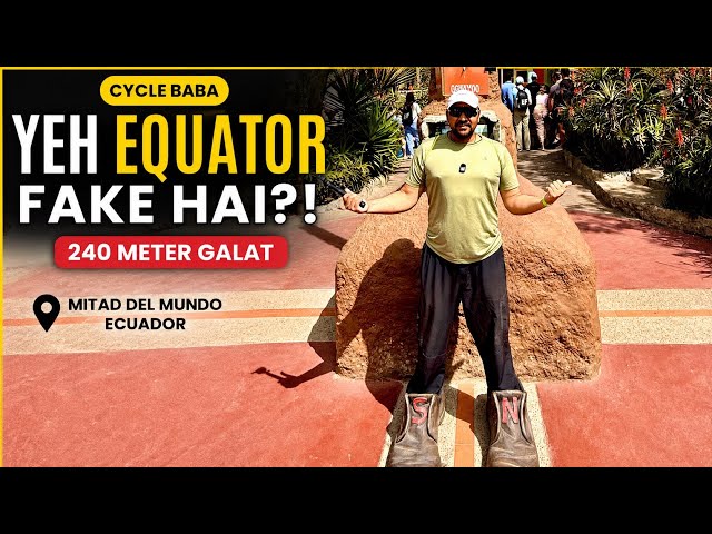
Friends, we have now arrived at Mitad del Mundo, which means “Middle of the Earth.”
These statues honour the scientists who helped identify and study this location. In the past, scientists debated the exact shape of the Earth. Some believed it was perfectly round, while others had different theories.
To settle the debate, France and Spain organised scientific expeditions. One team came here to Ecuador, while another travelled towards the southern regions of the world. Their measurements helped determine the Earth’s shape more accurately.
This historic monument, however, is not located on the exact Equator. The true Equator lies about 240 metres further north, near the museum we visited earlier. When the original scientists conducted their measurements, they did not have the highly accurate instruments available today.
In the centre stands a monument built in honour of those scientific missions. France contributed significantly to its construction.
Gravity is slightly weaker here than in many other places because the Earth bulges around the Equator. Another fascinating fact is that this region experiences almost exactly twelve hours of daylight and twelve hours of darkness throughout the year. Unlike many countries, there are no major seasonal changes in day length. Instead of four seasons, the climate is generally divided into two: the dry season and the rainy season.
The landscaping around the monument is beautiful. The trees and gardens are well maintained, and there is hardly any litter anywhere.
Before returning, I bought some coconut ice cream for $2. I was feeling hungry because I had only eaten a sandwich in the morning. By now it was already 1:00 PM, and I planned to find a proper meal once I returned to the city.
Soon our bus arrived. I got on board, turned my cap around, and continued enjoying the views.
You can see the municipal office building here. The Equator monument is behind us now.
The journey was enjoyable. We passed trucks, trees and beautiful city views before finally arriving back in Quito.
Our next activity was the city tour. I chose to do the city tour by bus because there are some safety concerns in the city centre. Mobile phones and cameras are sometimes snatched, so travelling with the organised tour felt like the safer option.
The city tour cost $15.
The buses themselves look fantastic. My bus was scheduled to leave at 2:00 PM, so before departure I decided to grab something to eat and drink.
Finally, I boarded the sightseeing bus and settled into my seat beneath the open roof, ready to continue exploring Quito.
It had started raining, so they closed the roof again. The bus was supposed to leave at 2:00 PM, but it finally departed at 2:15 PM. They took an extra 15 minutes, and surprisingly, I was the only passenger on board.
Now, as we travel through the city, I will show you the views, share some commentary, and point out the important places in Quito.
This is La Carolina, the area where I am staying. I am staying in one of these buildings, which I will show you later. The city centre is several kilometres to the south. When I first arrived by bicycle, I came to the northern side of the city. The La Carolina area is considered one of the safest parts of Quito.
Looking around, the greenery is impressive. The parks and plantations make the whole city feel pleasant and lively. Construction work is going on here, and it is being carried out with excellent safety measures. Everything is properly fenced and protected. These days, safety regulations are strictly followed, which is a good thing.
The city has well-designed cycling routes, with separate lanes for cyclists and pedestrians. Even the colours are different to avoid confusion. The bicycle lanes are painted green.
Look at the artwork painted on the walls. Quito stretches around 80 kilometres from north to south but is only about 5 kilometres wide from east to west.
This is a local market where visitors can buy souvenirs and other items.
Here is the first church that was built in this area. Suddenly, the weather has changed. Rain can start at any time here, and strong winds can appear without warning. This is quite common in equatorial regions located at high altitudes.
The guide explained that Ecuador’s flowers are among the finest in the world. Because the country lies so close to the Equator, flower farming thrives here.
There is a famous church here, and local legend says that if its construction is ever fully completed, the world will come to an end. It is a beautiful building, constructed between 1897 and 1920. Interestingly, some sections have intentionally been left unfinished because people believe that completing it would bring disaster.
The weather has become dramatic, but it adds to the atmosphere. Everywhere you go, you will see police officers standing guard, often in groups. Despite the security presence, crime remains a concern. Many shops also employ private security guards carrying firearms.
We are now travelling through the historic district of the city. Look at how the driver is manoeuvring this large bus through the narrow streets.
This area is filled with old houses, old neighbourhoods and old traditions. People are sitting outside their homes playing cards and enjoying life.
We have arrived near the city centre, around Plaza Central. Some of these historic buildings date back to 1775. This building is now the residence of the Vice President of the Republic. Security is very tight here, with soldiers, police officers and private security guards stationed throughout the area.
The flowers planted outside homes and public buildings make the city look even more beautiful.
This church was built in 1536. It stands at the centre of the city’s main square, known as Plaza de Armas, a feature commonly found in many Latin American cities.
The view of the city from here is incredible.
Eventually, we left the bus and climbed to the highest viewpoint overlooking Quito. There is a large statue here with wings spread wide, standing on top of a globe. A sign welcomes visitors to the “Centre of the Earth.”
The area with the tall modern buildings is La Carolina in the north. The historic centre lies below us, while the southern part of the city stretches out beyond it.
The city is approximately 80 kilometres long and around 8 kilometres wide in this valley.
The mountains surrounding Quito are volcanic mountains. Several of them have erupted in the past, and visitors can also hike up some of them.
This viewpoint is especially popular in the evening because the city lights create a spectacular sight after dark.
Now we move towards the southern side. There are fewer buildings and more trees in this direction.
Signboards here point towards several famous volcanoes, including Chimborazo, which stands at 6,263 metres, and Cotopaxi, located about 50 kilometres away. Other volcanoes such as Antisana are also visible. Ecuador has around 80 to 90 volcanoes, many of which are still active.
The statue looks beautiful from here.
This tunnel was built in 1978, while another tunnel nearby is even older. The city extends across the mountainsides, and engineers have built tunnels through the terrain to improve transportation.
Later, I decided to get a haircut. I met a Punjabi gentleman who had recently opened a barber shop just ten days earlier. He had only been back from India for about a month.
We chatted about life and business abroad. He was originally from Punjab and had taken the bold step of starting a business in Ecuador.
After the haircut, I looked much fresher.
Later, I visited an Indian restaurant called “Indian Taj Mahal.” The owner, a Punjabi lady, has been living in Ecuador for 17 years.
She shared many stories about helping Indians who became stranded while attempting illegal migration routes through Central and South America. Many people travelling illegally towards the United States get stuck in countries like Ecuador, Colombia and Panama.
She explained how she had helped dozens of young men return safely to India when stricter immigration policies prevented them from moving forward. Some of the stories were heartbreaking, involving dangerous encounters with criminal gangs and cartels operating along migration routes.
Her message was simple: think carefully before taking risky decisions in life.
She also offered help and guidance to anyone who might find themselves stranded in the region.
The restaurant serves excellent Indian food. For the past several days, I had been taking an Uber just to eat their parathas because good wheat flour is difficult to find in many parts of Latin America. Here, however, the food tasted just like home.
With that, my tour of Quito and the Middle of the Earth came to an end.
Tomorrow, I will leave Ecuador and continue my journey towards Colombia.
Until then, stay happy, stay busy, stay healthy and stay positive.
Jai Hind! Jai Bharat!