
CYCLING On World’s MOST Dangerous ROAD 😱 | DEATH ROAD Bolivia 🇧🇴 Ep.44
Thousands of people have died at this place. Until about 10 years ago, around 400–500 people used to die here every year. Bro, it has just snowed here recently. Look at this, the snow is still fresh. And the next day the police went there and…
Hello, Namaskar, Salaam, Sat Sri Akal, Ram Ram ji! Once again, welcome back to my YouTube channel. At the moment we are in Bolivia, in the capital city of La Paz. In the previous video you must have seen it. Today we are going to the Death Road — the most dangerous road in the world. It starts at around 4,800 metres above sea level, and from there we will ride downhill.
So the tours start from here. I have packed my bike and got everything ready. Now I will go with the tour group. The tour operators will take us in their vehicle. Usually they carry the bikes on their vehicle, but I told them I will take my own bike. I paid around ₹4,500 for this tour. Let’s see what kind of experience it will be. I really wanted to enjoy some downhill riding. It has been many days since I last did it.
I have been sitting here in La Paz for almost 10 days now. My health is still not completely fine, but I think it will work out. These beautiful streets are empty right now. After some time all the shops will open and the place will look completely different. It’s 7:00 in the morning and I have just stepped out.
Maybe all these people will also go with us. So friends, look at this beautiful artwork on the walls. I was supposed to go with this tour operator, but no one has arrived yet. They told me to come at 7:00, and now it is already 7:30. And look at these buildings — most of them are from the Spanish era, built when the Spanish ruled here. There are two streets like this and they look very beautiful. They have decorated them with colourful umbrellas. I will wait a little longer; otherwise I’ll just go back and sleep.

So finally someone came from another place after half an hour and called me. Then I came here. They have put my bike in the middle with the others.
Okay, now we will leave from here. I don’t know how far it is.
“Maybe 45 minutes or one hour. Today we will go over the mountain and start the tour there. Now my friends, chill out because we are on tour.”
They stopped the vehicle on the way. Some people here are from Colombia. They are saying if we want to buy anything, buy it now, because ahead we won’t find anything to eat. There is also a toll tax here. From here the national park area will start and tourists have to pay a fee of 50 Bolivianos. They will collect it a little further ahead. Usually the vehicles go fully packed. They have made a business out of this route.
Look at the mountains all around. Right now we have reached about 4,100 metres above sea level. There is water and some fruit here. I don’t know what it is called. If you know, tell me in the comments. They are calling it something like “grenadia”. We don’t get this in India. Inside it looks a bit like passion fruit.
I asked him the English name. He said there is no English name — it is a local fruit from Bolivia and Colombia. Let me open it and show you. It has seeds inside like this.
It looks like we have reached a glacier area. It feels like crossing Rohtang Pass in India. There is also a dam down there. They have brought us here now. There are three or four other cycling groups here as well. We will go with them.
It has just snowed here recently. And there are bears in this area too, so we have to be a little careful. We are now at around 4,700 metres above sea level. The snow is still fresh and hasn’t melted yet — it seems it snowed last night.
I have prepared my bike, but they gave me this helmet for safety. Everyone else is ready now. We will ride slowly because this is routine for us, but for them it is a tour.
Actually, I came here for just one reason. There is a cliff here where photos look amazing. I came mainly to take a photo at that spot. Otherwise, I didn’t really have a big reason to do this tour. I didn’t even bring all my luggage, only half of it.
Our whole group is now leaving from here. I guess I will have to go along with them now. They are making us stand in a line.
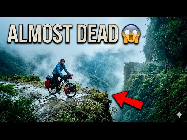
Look, they have even stopped my bike here. Our vehicle stopped for a while. The view here is absolutely amazing. Clouds are moving like this — just look at it. This is why it is called Death Road. In reality, it is extremely dangerous. Water flows across the road like this. Look at the rainwater coming down from the mountains and clouds.
This view reminds me of the road near Rohtang Pass in India, when you look down from the top.
Look at these scenes — waterfalls everywhere. It feels amazing to see them. Now the clouds have moved above us; earlier they were below us. Incredible! Totally worth the money. The waterfalls look beautiful. It honestly feels like I’m descending from Rohtang Pass.
It’s amazing. This is the entire group, and then there is my bike — it looks different from the rest.
So friends, they brought us to another place about 7–8 kilometres ahead. From here the actual Death Road begins. From here people start going downhill. The view from here is spectacular.
From here we will descend about 2,000 metres on this gravel road. That’s why it is called Death Valley or Death Road.
Alright friends, I have worn the helmet again and prepared my bike. Why it is called Death Road — I will explain that on the way. Right now I have this helmet on, so you might not hear my voice clearly.
The helmet is compulsory. I told them to give me a simple one, but they insisted on this one.
Our whole group is ready now. There are four Bolivians and two guides with us. The route will be around 40 kilometres long, and we will ride all the way downhill.
They are making a design of a llama. The tour seems sponsored by DJI because they are using many DJI products.
And now you will see the beautiful road from here. From here we have to ride 40 kilometres on this route going downhill.
The road goes downhill, so it will be fun. I will ride at the back slowly.
Hey, enjoy, enjoy, enjoy… no problem.
Oh my goodness… look at this. At many places here people have died. This one seems to be a biker. Look at this waterfall — the water is coming down so strongly, some from 500 metres high and some from 400 metres.
And this is Death Road, Bolivia.
Welcome to Death Road, Bolivia.
It may look beautiful from afar, but it is actually very dangerous. Look at this landslide — it’s extremely risky. We are going down slowly. Look at the waterfalls flowing across the road.
You can see writing here in Hebrew. A lot of Israeli travellers used to visit this place. Many people lost their lives on this road, and these memorials have been made in their memory.
This is the most dangerous road here. There is hardly any road more dangerous than this. Just imagine how they must have cut through these mountains to build it at such a height.
In 2008, two buses fell into the gorge here, and around 100 people died together. Thousands of people have died at this place. Look how the water is coming down from above.
Oh wow… this is incredible.
Alright, let’s move ahead to the most dangerous section.
Oh my goodness… oh my goodness.
(Laughs)
So friends, let me explain a little why this road is called Death Road.
This road was built around 1980. Bolivia had a war with Paraguay, and the prisoners captured during that war were made to build this road. Until about ten years ago, vehicles used to travel on this road regularly.
This was the only route connecting North Bolivia with the rest of the country. There were farms in that region, so people needed a way to transport goods. That’s why prisoners were forced to work and build this highway.
The road runs from about 1,900 metres above sea level up to 4,700 metres, and then it descends again towards La Paz at around 3,700 metres.
Until about ten years ago, around 400–500 people died here every year. That’s how dangerous this road was.
Building this road itself must have been extremely difficult. Imagine cutting through mountains like this to create a road. It seems almost impossible. Yet it was built by hand by prisoners in 1980 — basically forced labour.
Now we have come to the other side of the Andes Mountains. And today I am feeling really good because I can finally breathe properly. There is greenery here and plenty of oxygen.
For the past month I have been struggling for oxygen. I’m not joking. That’s why I always say — plant trees. Today I can actually feel that I’m breathing properly.
Even when I was in La Paz for the last 8–10 days, I still couldn’t breathe properly. At night I kept waking up and drinking water because of breathing issues.
Right now I’m at around 2,500 metres above sea level. All the mountains and waterfalls you see — I actually passed underneath many of these waterfalls while riding down.
I have descended a lot already — almost 1,500 metres down.
This helmet is really bothering me now. I can’t speak properly and can’t enjoy properly either.
Honestly, this really is Death Road.
I stopped for a while on the way. Just look at this view — it’s amazing. Some people are still coming down from here.
Alright, I’ve got my bike ready again. One good thing is that I washed the bike here. These people wash all the bikes before taking them back.
Now we will return to La Paz, which is about 100 kilometres from here.
On the way they stopped for lunch. Look, there is a parrot sitting up there. See how playful it is. They stopped us at a resort along the road. There is a buffet here, but honestly there is nothing suitable for me.
This area now starts to feel like the Amazon region. They have a swimming pool and showers here. It’s already 5:00 PM and they are calling it lunch. Lunch is included in the package, but there was nothing I could really eat because everything was non-vegetarian.
So I just drank some water and left.
All the food in the buffet was non-vegetarian.
So after finishing the tour, I returned to my room. Let me tell you a small story about something that happened to me.
When I was in Salar de Uyuni, my phone was snatched. But the people who stole it were inexperienced. They didn’t switch the phone off.
I had another iPhone with me. I went to a nearby shop and asked for Wi-Fi. Using Wi-Fi, I checked the location of my phone and could see where it was moving.
Then I went to the nearby police station. The police told me that since it was inside Salar, the thieves couldn’t escape easily because there are very limited places to go. Eventually they would stay at some hotel, and the police would call the hotels and stop them there.
That’s exactly what happened. Around 10 PM, they reached a hotel deep inside Salar, almost 40 km inside. The hotel manager stopped them there. The next day the police went there, took my phone from them, and sent it back to me by car.
Even the driver who brought the phone asked me for money. But that’s fair because he travelled all the way. I gave him $50 and got my phone back.
After that there were elections happening there, and the police also advised me to leave. So I decided to come directly from Salar de Uyuni to La Paz.
I have been in La Paz for about 10 days now, but my health is still not completely fine. Because of the high altitude, I don’t feel hungry at all. I don’t even feel like editing videos.
There are many Indian restaurants here. In the next video I will show them to you. There are about four Indian restaurants around the place where I am staying, right in the city centre.
So sometimes I eat at one restaurant, sometimes another, and then I come back to my room and sleep. I don’t know what exactly is going on with my health.
Anyway, let’s end today’s video here.
Until next time — stay happy, stay busy, stay positive, and stay healthy.
Jai Hind! 🇮🇳